
Earth observation for environmental analysis and protection
 Image courtesy Airbus Defence and Space
At the COP 27 climate conference in Sharm-El-Sheikh in November, political leaders, as well as industry and academia participants discussed how to promote sustainable agriculture, prevent deforestation, protect our oceans, stamp out illegal mining and more.

Yet with the Earth’s surface spanning 196.9 million square miles, how exactly can we understand what is going on in remote and hard-to-reach ecosystems? After all, it is not possible to put an auditor behind every tree in a forest.
With recent advances in satellite technology, today’s commercial satellites can capture highly detailed images with up to 30cm resolution, spanning tens of kilometres in diameter. What is more, they boast extremely accurate geolocation – precise up to 3.5 metres – ensuring that anything spotted on an image can easily be mapped to a corresponding set of coordinates. So, it is no surprise that as we race to protect our environment from further damage, satellite-derived imagery is becoming a crucial tool for environmental analysis and protection.
Shedding light on our oceans
Our seas and oceans are being ravaged by climate change. Rising sea levels and warming water temperatures are causing harmful side effects including toxic algae blooms and coral bleaching. Add in the issues of overfishing and pollution, entire species are on the verge of extinction.
Water covers almost three-quarters of the Earth’s surface. The vastness of our seas and oceans means it is impossible to gain a holistic understanding of marine ecosystems while on the ground – or in the water for that matter. Satellite-derived imagery is truly the only way to do so.
One way satellites help protect the health of our oceans is through maritime surveillance. Commercial fishing trawlers are legally required to have automatic identification system transponders fitted and secure to their boat. However, lawbreaking vessels often disable these to evade detection, leaving authorities in the dark about their true activities. Earth observation can bridge this gap, enabling governments and NGOs to closely monitor illegal fishing hot spots and identify offending vessels.
In addition to monitoring illegal activity in our oceans, satellite imagery enables us to better understand the state of coastlines – estimating water depth, quality and clarity. Images can be retrospectively colourised based on multispectral data, revealing hidden insights that are not visible to the naked eye. In figure one, Airbus’ deep blue multispectral band offers viewers a clearer understanding of depth and improves safety in maritime navigation.
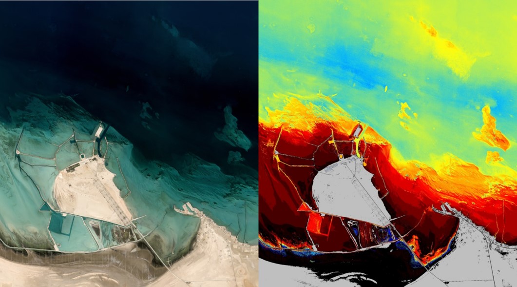
Figure 1: ‘Deep Blue’ spectral band used to estimate water depth – Persian Gulf, February 2022, Pléiades Neo
Transforming agriculture
Back on dry land, the addition of new multispectral channels is also supporting sustainable agriculture. In figure 2, the analysis of Airbus’ red edge spectral band reveals for instance precise levels of detail of chlorophyll in vegetation. Monitoring leaf chlorophyll content is essential to evaluate plant nitrogen status over time and enable farmers to take corrective action to improve crop health.
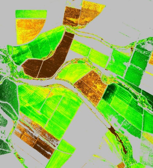

Figure 2: Leaf chlorophyll content – Merida, Mexico, Pléiades Neo
It is worth noting that by combining the spectral richness of the image with crop modelling, it is possible to create full maps of so-called biophysical parameters characterising the state and health of vegetation.
For example, in figure 3, we use the same image as the one used in figure 2 to measure leaf area index, in other words the quantity of foliage on a unit of land. This information will help farmers make more informed decisions when it comes to addressing specific needs of their crop within the same field. Typical benefits include, for instance, crop irrigation in a given location, enabling more sustainable water use.
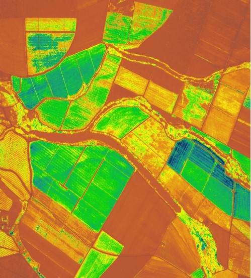

Figure 3: Leaf Area Index) – Merida, Mexico, Pléiades Neo
Managing natural disasters
Floods, drought, avalanches, hurricanes, landslides, forest fires and other natural disasters are becoming much more common due to climate change – even in areas previously unaffected by extreme weather.
There really is no alternative to Earth observation for effective data gathering during natural disasters – particularly when assessing the situation on the ground is considered too dangerous. It is worth noting that recent advances in satellite technology have radically increased satellite tasking agility. Urgent tasking requests can now be processed in as little as 30 minutes – significantly enhancing satellites’ utility in emergency response and natural disaster scenarios.
Take the example of a hurricane in Mananjary, Madagascar earlier this year. Using satellite imagery, local authorities and NGOs were quickly able to ascertain which areas had been flooded, dispatching aid and plotting safe access routes accordingly.
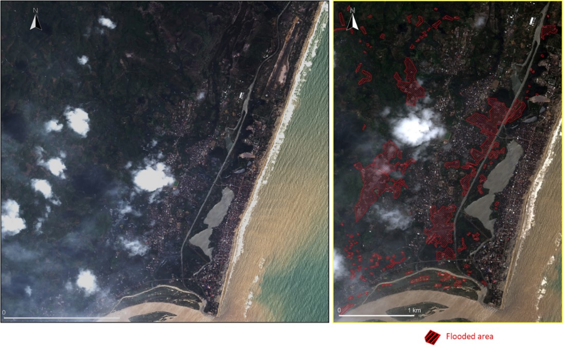
Figures 5 and 6: Monitoring flooding – Mananjary, Madagascar, February 2022, Pléiades Neo

Following the immediate aftermath of the hurricane and flooding, authorities again turned to satellite imagery to survey the scale of the damage. For instance, by comparing figures 7 and 8, they could spot which buildings suffered damage and plan reconstruction work accordingly.
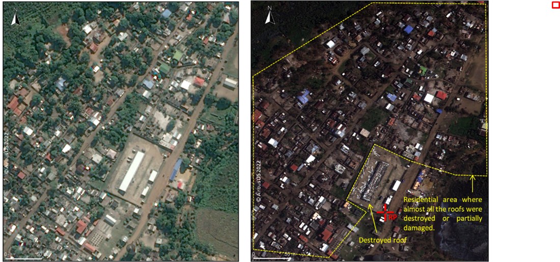
Figure 7: Mananjary, Madagascar, June 2021, Pléiades
Figure 8: Mananjary, Madagascar, February 2022, Pléiades Neo
What is next?
We are at a major inflection point for the use of satellite imagery. Thanks to recent technological developments, the quality of the images is now sufficiently high to reveal even the most precise details. At the same time, advances in big data technology and AI mean it is possible to process and analyse huge quantities of data to spot trends and anomalies.
It is now up to governments, public institutions, NGOs and private companies to harness this technology to leverage the power of the data for use cases that are not just reactive but can be used proactively over time. Using both satellite and supply chain data together, companies can engage with their suppliers to address deforestation, or switch to a more sustainable alternative.
There is no reason why this end-to-end approach could not be replicated in other areas. For instance, mitigating the impact of natural catastrophes like landslides, avalanches and volcanic eruptions, which can often be prepared and their impact lessened based on geographical features that can be analysed from space.
Alternatively, satellite data could be used by governments to support the development of sustainable cities – like the identification and prevention of urban heat islands or ensuring development occurs away from flood prone areas by capturing elevation levels.
Overall, when it comes to using satellite data to support environmental protection and analysis, the possibilities are endless. Success will hinge on public-private sector collaboration, ensuring stakeholders feel empowered to work with satellite imagery.